
WINTER BITES
Brutal cold snap confronts SA as forecasters issue snow, thunderstorm warnings
KwaZulu-Natal is on alert following strong winds resembling a tornado ripping through Inanda and surrounding areas, and the South African Weather Service has warned of frigid temperatures and snow in some parts of the country on Thursday, making for precarious driving conditions and possible road closures in the northeastern regions of the Eastern Cape.
Parts of South Africa and Lesotho are in for a brutal cold snap in the next few days, the South African Weather Service (SAWS) warned on Wednesday. Snow and wet weather is set to hit the northeastern parts of the Eastern Cape on Thursday.
‘Bitterly cold conditions’
Counterparts of the SAWS in Lesotho have issued a forecast for “bitterly cold temperatures with heavy snowfall over Lethoso”, the SAWS said.
These conditions may spill over to QwaQwa in the northeastern Free State, it added.
“Some road network and mountain passes connecting communities on the southern Drakensberg in the Eastern Cape could be closed on Thursday, following the potential disruptive snow on the roads and railways, especially during the morning hours.
“Areas of potential impacts include Molteno, Barkly East, Lady Grey and Matatiele, and there could be isolated loss of livestock in this northern region.”
SAWS forecaster Lehlohonolo Thobela told Daily Maverick that these areas could see maximum temperatures of about 14°C and a minimum of 10°C on Wednesday. He was unable to say how much snow is expected in these regions.
Yellow level 2 warning for snow over the Eastern Cape, 29-06-2023. Valid until 15:00 SAST. pic.twitter.com/LykmIBJn8b
— SA Weather Service (@SAWeatherServic) June 28, 2023
These conditions are expected to result from the passage of a cut-off low which is currently situated along the west coast of South Africa. Very cold temperatures have already been recorded in the western regions of the Free State and North West.
The SAWS said the icy temperatures could claim livestock in the western region of the Northern Cape and Western Cape.
Additionally, the weather service warned of “bursts of showers and excessive lightning” that may cause localised damage to infrastructure and settlements, with isolated thunderstorms potentially producing “strong, damaging” winds over these regions.
Yellow level 4 warning for severe thunderstorms over the Eastern Cape, 28-06-2023. Valid until 23:00 SAST. pic.twitter.com/I3gtPxFx7r
— SA Weather Service (@SAWeatherServic) June 28, 2023
Disruptive rainfall
Warnings of heavy rainfall were issued for parts of KwaZulu-Natal and the Eastern Cape on Tuesday.
SAWS forecaster Kgoloselo Mahlangu told Daily Maverick that areas along the south coast, including Scottburgh, Paddock, Margate and Port Shepstone, recorded large amounts of rain and flooding in some places, on Tuesday.
The SAWS had issued an Orange Level 6 alert for the Ugu District Municipality on Tuesday. A Yellow Level 2 warning has been issued for eThekwini Metro Municipality and Ugu District Municipality for disruptive rain on Wednesday, as rainy conditions are set to continue on-and-off during the day.
“The surface is already saturated from [Tuesday’s rainfall] – so any additional rainfall in these parts will cause the run-off of water and could result in some flash flooding,” said Mahlangu.
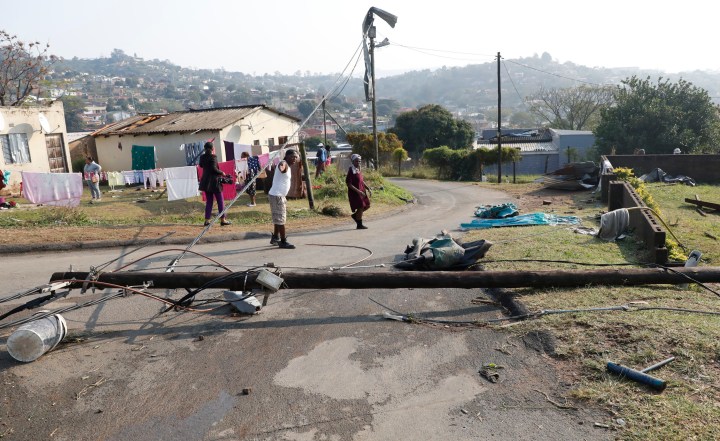
On Tuesday, KZN’s Department of Cooperative Governance and Traditional Affairs (Cogta) said heavy rainfall accompanied by strong winds had caused “significant damage in various parts of the province, with the Inanda township in the north of Durban being the most severely affected”.
“Preliminary reports indicate that several homes have been damaged, and some individuals have sustained injuries.”
KZN premier Nomusa Dube-Ncube and eThekwini mayor Mxolisi Kaunda visited Inanda on Wednesday morning to assess the damage.
Reports of strong winds that resembled a tornado ripped through Inanda and the surrounding areas on Tuesday afternoon. Mahlangu said on Wednesday that SAWS forecasters had not finished evaluating video footage of the incident and could not yet verify the tornado-like activity.
[COMING UP]
KwaZulu-Natal Emergency Medical Services spokesperson Robert Mckenzie joins us shortly to discuss how they help communities affected by heavy rain and storm winds in that lashed Ethekwini and surroundings.#MorningLive #SABCNews pic.twitter.com/u1WTvR6WmZ
— MorningLiveSABC (@MorningLiveSABC) June 28, 2023
On Wednesday, Gift of the Givers teams were expected to visit areas in KwaZulu-Natal affected by the storm and heavy downpours on Tuesday.
“Assessment was not possible [on Tuesday] with the ongoing rain, traffic volumes and darkness settling in,” Gift of the Givers founder Dr Imtiaz Sooliman said.

The flooded Rielvlei picnic area in Cape Town’s Table Bay Nature Reserve on 22 June 2023. (Photo: Gallo Images / Ziyaad Douglas)
“Inanda is the epicentre of the destruction including Bambhayi, Dube Village, Amaoti and Ohlanga. Folweni near Umbumbulu, Pennington near Umzinto and Oshiweni near Port Shepstone are the other affected areas. Our intervention teams are on their way for site visits while the warehouse teams are at work preparing aid for distribution,” said Sooliman.
Gift of the Givers is on standby to intervene in Inanda, #KZN 📍 following the Tornado 🌪 this afternoon. Initial feedback is that Bhambayi and Mawoti have been badly affected. At present, the teams are awaiting feedback from disaster management officials and community members. pic.twitter.com/0vxSUGrLjG
— Gift of the Givers (@GiftoftheGivers) June 27, 2023
Wet, wet, wet
Meanwhile, this year, the Western Cape has had its highest rainfall since 1976.
Read more in Daily Maverick: Western Cape: Rainfall this year is breaking records in SA’s ‘most disaster-prone’ province
Heavy rainfall in the province between 14 and 19 June claimed two lives and left thousands displaced, as disaster management teams and aid organisations continued relief efforts, Daily Maverick reported. The Cape Winelands and the West Coast were hit hardest by a series of cold fronts which led to heavy rain and localised flooding. DM


Comments - Please login in order to comment.