
NATIONAL STATE OF DISASTER
SA Weather Service issues alerts as government responds to flood chaos across the country
The government has declared a National State of Disaster to enable an ‘intensive, coordinated response’ to the floods that have devastated parts of seven of South Africa’s nine provinces.
The ongoing above-normal rainfall in South Africa was classified as a national disaster by the National Disaster Management Centre on Monday, 13 February.
The Presidency said Mpumalanga, the Eastern Cape, Gauteng, KwaZulu-Natal, Limpopo, the Northern Cape and North West had been affected by flooding, brought on by heavy rainfall as a result of the La Niña weather phenomenon.
Read more in Daily Maverick: “Rain-battered provinces record mounting death and destruction as state declares National State of Disaster”
“Over the last week, another cut-off low together with ample tropical moisture from a deep low pressure over Botswana continued to result in rainfall over areas that have received significant rainfall since the start of February,” weather forecaster Wayne Venter from the SA Weather Service told Daily Maverick on Sunday, 19 February.
A cut-off low-pressure system developed in parts of the country on Wednesday, 8 February. This is a weather system that is notorious for causing severe weather, including heavy rainfall and flooding.
The SA Weather Service is the only mandated regulatory body that can issue weather warnings in the country.
Read more in Daily Maverick: “Extreme weather on the way — and events like this are likely to become more frequent”
Venter said flooding had occurred over parts of the Eastern Cape (Komani and the Wild Coast), parts of KwaZulu-Natal (especially Newcastle), the northeastern Free State, parts of the lowveld and escarpment areas of Mpumalanga, the Mpumalanga highveld (especially over the catchment areas of the Vaal Dam), Gauteng (especially the southern parts) and in places in the North West.
“Even though rainfall was not as extreme as the previous week, soil moisture was very high and any amount of rainfall led to localised flooding in places,” he said.
Gauteng
The Department of Water and Sanitation announced on Sunday, 19 February, that 12 flood gates would remain open at Vaal Dam and outflow at the Bloemhof Dam had increased to 3,000 cubic metres per second (cumec).
“Rainfall was persistent over areas for several days causing the Vaal catchment to overflow into the Vaal Dam and resulted in several Vaal Dam sluice gates to be opened, which will result in flooding downstream along the Vaal River,” Venter said.
Kliprivier inloop by Vaalrivier 19-02-2023📸Rudi Trauernicht @peoples_weather @SAWeatherServic @VoxWeatherZa @maroelamedia @OvervaalStereo @eNCA pic.twitter.com/JP40xO3QRo
— ReenvalSA (@ReenvalSA) February 19, 2023
“The water release increases are necessitated by the continuous and intense rainfall that is causing rivers to overflow and dams to spill,” the department said in a statement.
“The Vaal and Orange river system is experiencing rapid rising water levels due to the heavy rains and the department continues to assess and implement measures to mitigate effects of these floods on its infrastructure and guarantee full capacity on its storage reservoirs after the rainfall season.”
At midday on 19 February, the Vaal Dam’s capacity was at a whopping 114.2 %, with inflow at 2,928 cumec and outflow at 2,165 cumec.

Actual inflow, predicted inflow, actual outflow and predicted outflow and dam capacity of the Vaal Dam as of 19 February 2023. On Sunday, 19 February, the Vaal Dam was 114.2% full with 12 flood gates open. (Source: Department of Water and Sanitation)
The Department of Water and Sanitation advised residents of settlements and in towns along the banks of the lower Vaal and lower Orange rivers to consider evacuating or moving to higher places that are at least above the one-in-20-year flood line, “a level at which people would likely be safer to be reached by water emanating from the releases”.
“Since rainfall and floods are a natural phenomenon and therefore control of the events may be limited, the department advises against putting essential services and human settlements within parts of the floodplains where there is likelihood of frequent flooding, that is within a one-in-100-year floodline,” the department said.

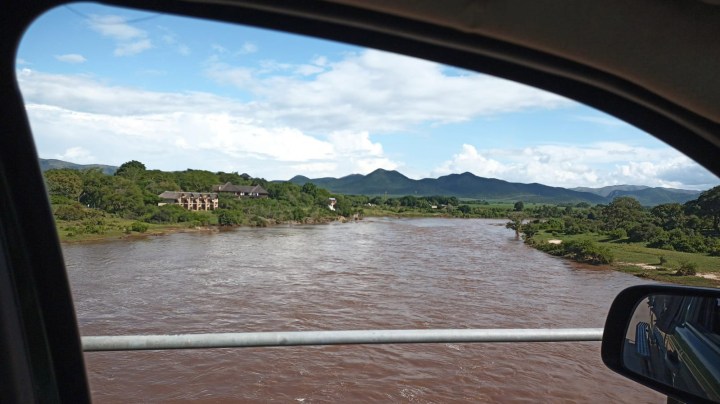
Christo Engelbrecht’s holiday house pictured Sunday, 19 February, just above Parys on the Vaal River as over 2,500 cubic meters per second of water flowed past his house from the Vaal Dam after 12 sluice gates were opened. (Photo: Christo Engelbrecht)

Christo Engelbrecht’s holiday house, just above Parys on the Vaal River, on Saturday evening, 18 February, after heavy rainfall. (Photo: Christo Engelbrecht)
Visit Daily Maverick’s home page for more news, analysis and investigations
‘Too much water’
Christo Engelbrecht says he had 2,500 cumecs of water flow past his house, which is on the Vaal River just above Parys and about 120km from the Vaal Dam. Most of the water came from the Vaal Dam.
“As a young boy and a Likkewaan Canoe Club member, I either had to walk, run or cycle [to get to the water to paddle], and now I can do it from my verandah,” Engelbrecht joked. “I often got into trouble for paddling on swollen rivers. This weekend though … Too much water, even for me.”
Christo Engelbrecht paddling out of what should be his garden, at his house in Parys near the Vaal River, after 12 flood gates were opened at the Vaal Dam after persistent rainfall this week #flooding #saweatherservice #DWS #dailymaverick pic.twitter.com/QzLibxy2YY
— Julia Evans (@Julia_J_Evans) February 19, 2023
KwaZulu-Natal
The SA Weather Service issued a yellow Level 2 warning for rain in parts of KwaZulu-Natal from 11am to 9pm on Sunday, which means there’s a high likelihood of rain, but the impact is expected to be minor.
“Scattered showers and thundershowers are expected over the
northern parts of KZN today with some stations having recorded an
accumulation of more than 20mm in the past 24 hours,” said the SA Weather Service. “Some rain is still expected today, which may result in localised flooding over the northern parts of the province, as the soil is still saturated.”
The effects of this weather include the possibility of flooding of some formal and informal settlements and low-lying bridges.
Warning: Yellow level 2 warning for disruptive rainfall over the northern parts of KwaZulu-Natal for today 19 February 2023. pic.twitter.com/TDVex5b7IU
— SA Weather Service (@SAWeatherServic) February 19, 2023
The SA Weather Service warned that difficult driving conditions should be expected on dirt roads. Poor visibility and slippery roads could lead to minor motor vehicle accidents.
Rain could damage mud-based houses, and mudslides and soil erosion are possible, it said.

Standerton, which lies on the banks of the Vaal River in Mpumalanga, on Friday, 17 February 2023, after heavy rainfall. (Photo: Cindy de Bruin)

Flooding in Standerton on Friday, 17 February 2023. (Photo: Cindy de Bruin)
Mpumalanga
The SA Weather Service put out a weather alert on Sunday that severe thunderstorms could be expected in parts of Mpumalanga – including Amersfoort, eMkhondo, Carolina, eNtokozweni and Sabie, all the way up to Bushbuckridge.
It issued a Level 4 warning for this area, which means there is a low likelihood of the severe thunderstorms occurring. If they do, however, the impact could be significant and may include damage to homes, falling trees as well as hail damage to cars and other infrastructure.
The SA Weather Service has advised people in the area to stay indoors and off the roads. “Avoid crossing rivers and swollen streams where water is above your ankles. If trapped in a vehicle during a flood, abandon it and climb to higher ground. In buildings, move valuables to a safe place above the expected flood level.”

Standerton on Friday, 17 February 2023, after heavy rainfall. (Photo: Cindy de Bruin)
Northern Cape
The SA Weather Service has put out a weather alert that Sutherland in the Karoo Hoogland municipality in Northern Cape can expect damaging winds to level two (high possibility of occurring, minor impact) on Monday.
Cross winds on exposed high-level roads and bridges are expected, which will cause problems for high-sided vehicles, especially on the N1 between Worcester and Beaufort-West, said the SA Weather Service.
Power and communication interruptions are also likely.
Limpopo
Witness Tiva, spokesperson for the Limpopo Department of Public Works Roads and Infrastructure, told Daily Maverick the damage to road infrastructure in Limpopo includes “complete erosion” on some roads. Other roads have been partly cut off, with damaged drainage causing potholes.
“The floods have reversed the work of rehabilitation and patching of potholes that we launched in August last year through operation Thiba Mekoti Distseleng,” he said.
Tiva said teams were continuing with assessments. By Sunday, 1o bridges had been washed away and 202 roads were damaged or eroded across all five districts in Limpopo (Waterberg, Capricorn, Mopani, Sekhukhune and Vhembe districts).
“Mopani and Sekhukhune are the hardest hit,” said Tiva. “The department, together with its entity Roads Agency Limpopo, are prioritising some roads in terms of regravelling and patching of potholes.
“We also hope that the national government’s declaration of the National State of Disaster will enable us to speedily intervene to repair damaged bridges as well as critical roads.”
The SA Weather Service put out a weather alert that parts of Limpopo – including Ba-Phalaborwa, Greater Giyani, Makhado, Blouberg and Thulamela Municipality all the way up to Musina Municipality – could expect “disruptive rain” from 10am to midnight on Sunday.
North West
Heavy rainfall and flooding this week in Deelpan, Tswaing Local Municipality has led to some families being evacuated, Dineo Thapelo, cooperative governance and traditional affairs spokesperson for North West, told Daily Maverick. Others have opted to stay with friends and relatives.
What’s to come
“Fortunately, these weather systems are expected to slowly move out on Monday with isolated storms still in the forecast, especially during Monday afternoon over the central and eastern parts of the country,” Venter said.
“But no rainfall is expected from Tuesday across the eastern and central interior of the country until the end of the work week.”
Venter said a cold front was expected to bring some rain to the Western Cape on Monday, with heavier falls likely over the Cape metro, Overberg and southern parts of the Cape winelands, where a Level 2 warning for disruptive rain has been issued by the SA Weather Service.
“This front is also expected to bring strong to gale-force winds along the Western Cape southwest and south coasts as well as rough sea conditions with wave heights of 4m to 5m,” said Venter. “This is especially of importance to the marine community.” DM/OBP


Comments - Please login in order to comment.